Welcome
Welcome to the Lowell, Ohio History website. This website covers the history of Lowell and Adams Township in Washington County, Ohio. Our purpose is to educate and assist our visitors about our community and preserve our local history.


Lowell's Founder
Perez Barnum Buell
Overview of Adams Township
Adams Township was established in 1793 and incorporated by the Court of Quarter Sessions in March 1797. The Township originally included parts of Salem and Muskingum Townships. In 1877, part of Union Township was annexed into it. The Township was likely named after President John Adams.
The earliest settlers in Adams Township included the Coburns, Allisons, Dodges, Davises, Fryes, Kinneys, Owens, Masons, Devols, Spragues, Stephen Frost, Joseph and David Wells, Gilbert Semon, George Fox, Alfred Hall, John J. Wood, David M. Reed, Albert Chandler, Philip Mattern, Jacob Schneider, and Frank Buell.
Located in the northern part of the county, it is bordered by Waterford, Watertown, Muskingum, and Salem Townships in Washington County; and Jackson Township in Noble County.
The population was 1,830 on the 2000 Census. The current trustees of the township are Jeff Anthony, Wayne Isner, and Josh Harris. The clerk is Carrie Tullius.
Communities and Post Offices:
Buell’s Lowell/Lowell (1851-)
“Adams” > Carroll (1830-1837) > Lowell/Upper Lowell (1837-?)
Cats Creek Mills (1813-1817)
Fair Play/Equity (1888-1902)
Settlements (Ridges, Hills, and Hollows): Lang Ridge, Lynch Hill, Olloch Hill
Streams, Creeks, Rivers, Runs: Big Run, Cats Creek, Congress Run, Straight Run, Bear Run,
Right & South branches of Wolf Creek, Rainbow Creek, Muskingum River, Coal Run, Cairns Run
Dams: Lowell Dam (Lock #3)
Islands: Buell
State Routes: 60, 530
County Roads: 56, 60, 76, 79
Introduction to Lowell, Ohio
The first settlement in Adams Township was made under the direction of the Ohio Company of Associates. This organization was formed by officers of the Revolutionary Army to settle in the area north of the Ohio River. They sent Rev. Manasseh Cutler of Ipswich, Massachusetts, to persuade the Continental Congress to accept their military certificates as payment for land in the West. Before carrying out this task, Rev. Cutler cooperated with Congress in the writing of the Ordinance of 1787 for the government of lands northwest of the Ohio River. He then succeeded in securing 1.5 million acres of land along the Muskingum and Ohio rivers in exchange for the military certificates. As soon as this tract was purchased, the Ohio Company appointed Rufus Putnam to be the superintendent of their migration. On April 7, 1788, 48 pioneer settlers arrived at Marietta.
The Marietta Pioneers saw the site of Lowell for the first time when an exploring party came up the Muskingum River on June 27, 1788. Col. John May recorded their opinion: “Some of our gentlemen went up the Muskingum ten miles, and came back highly pleased. They say the lands are abundantly better than where we are clearing.”
In 1791 the Natives started warfare against the white settlers throughout the Ohio valley with the killing of 12 people at Big Bottom, near the present village of Stockport. As a result of the killings, the arrival of new settlers to the Ohio Company Purchase stopped nearly completely. To increase the number of defenders and to establish outposts against attacks, the Ohio Company adopted the plan of donating land to new settlers. For this purpose, Congress turned over to the Directors of the Ohio Company a Donation Tract 21 miles long by 8 miles wide, containing 100,000 acres in the northern part of the purchase. Each settler received 100 acres on the condition that they build a house within five years, plant 70 fruit trees and clear 20 acres of land within three years, and provide for defense against the Natives.
When a group of people wanted to settle together in the Donation Tract, the Ohio Company assigned them an allotment of land surveyed into lots of various sizes. Each settler received lots totaling 100 acres. Lowell stands in the Cats Creek and Bear Creek allotments of the Donation Tract. The first allotments to be settled in Adams Township were the Rainbow Allotment and the Allotment Northwest of Wolf Creek Mills across the river from Lowell. Donation lots were drawn in 1789, but the first settlement was made by four families and four single men who moved into a fortified settlement centrally located to their lots, near the south end of the Muskingum River bridge in April 1795.
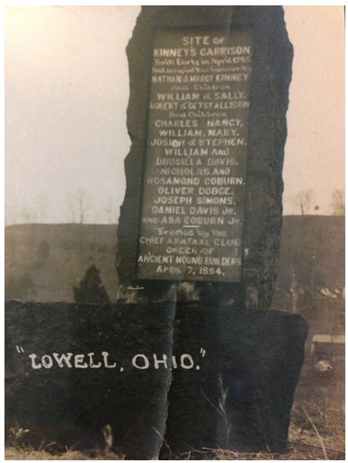
These pioneer settlers of Adams Township lived in four cabins on the land of Nathan Kinney, a native of Nova Scotia, Canada, whose family included his wife, Margy, and their children, William and Sally. Nathan came to Marietta in 1789 and resided during the Indian War at Fort Frye. He drew lot number 23 in the Cats Creek allotment. Joseph Simons, who drew lot number 10 in the same allotment, lived in the Kinney cabin. Nicholas Coburn, his wife Rosamund, and his brother Asa, occupied another cabin. Nicholas Coburn arrived in 1788 and lived at Fort Frye until he moved to the Kinney lot. He drew lot number 27 in the Cats Creek allotment and his brother drew number 25. William and Drusilla Davis shared their cabin with William’s brother Daniel. The brothers owned lot numbers 8 and 12 in the Bear Creek allotment. Robert Allison and his wife Betsy occupied the fourth cabin with their children - Charles, Nancy, William, Mary, Josiah, and Stephen - and a single man by the name of Oliver Dodge, one of the 48 pioneers of Marietta.
Robert Allison came from Pennsylvania in the fall of 1788 and lived in Campus Martius during the Indian War. He drew lot number 14 in the Cats Creek allotment. Robert’s daughter Nancy was born in Fayette County, Pennsylvania, on October 22, 1784. She married Stephen Frost, on December 18, 1800, and died at Lowell on February 10, 1892, at the age of 107 years, 3 months, and 19 days. She is buried in the old section of Greenlawn Cemetery.
The four cabins of this pioneer colony stood in a row at the top of the river bank. Be ginning with the upper cabin and naming the owners downstream, they were Coburn, Kinney, Davis, and Allison. Rows of pickets connected the cabins and extended from the two end cabins to the river. The pickets consisted of heavy logs placed vertically in a trench with the earth packed tightly at the base. By this means the pioneers were protected in their access to the river for drinking water and for transportation. General "Mad" Anthony Wayne defeated the Indians at Fallen Timbers west of the present city of Toledo on August 20, 1794. After Wayne completed the treaty of Greenville on August 5, 1795, the settlers left Kinney's garrison to reside on their own lands. Kinney operated a ferry at his residence in 1795.
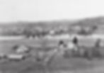
The fortification stood at the foot of Cats Creek Island. Cats Creek emptied into the Muskingum below the present dam, and the mouth of the creek was diverted to its present location when the dam and locks were built. To mark the site of the Kinney Garrison, a monument was erected on the south bank of the Muskingum River on April 7, 1894, by the Chief Arataxl Club, Order of Ancient Mound Builders. This monument was dislodged by the flood of 1913 and later replaced in a block of concrete. On April 7, 1938, the citizens of Lowell erected another monument on Main Street.
Washington County was established on July 26, 1788. Adams Township was incorporated by the Court of Quarter Sessions at Marietta in March 1797. Originally it included Salem, Muskingum, and parts of other townships. The name honors President John Adams, who was inaugurated in 1797. The first religious services in the township were conducted by Rev. Daniel Story of Marietta soon after the settlers arrived. Enoch Wing taught the first school in his cabin near the mouth of Cats Creek about 1797. The first schoolhouse was built about 1800. The f irst goods were sold in Adams Township by S. N. Merriam in 1816. Elijah Short opened the first store in 1822 near the mouth of Cats Creek.
Two brothers, Salmon A. and Perez Barnum Buell came to Adams Township in about 1816. They were very influential in the development of the community. Salmon was born in Ithaca, New York, on August 11, 1794, and Perez was born in Ithaca, New York on June 23, 1796. These brothers were seventh generation descendants of William Buell, who came from England to Massachusetts in 1630. Their father was the Hon. Salmon Buell, lawyer, judge, and senator.
The brothers came west in search of opportunity. When Perez Barnum was coming through Parkersburg on horseback, he saw a girl riding past him. Both stopped and looked back. She was Eliza Rector. They were married in 1818. Salmon married Eliza Buell, daughter of Timothy Buell of Marietta, on April 13, 1817. They were the parents of Major General Don Carlos Buell.
Soon after their marriages, the brothers built a large, square brick house on the river bank opposite the south end of Market Street. The Buell house was the one later known as the Dutton house. Both families lived in this house until the death of Salmon in the cholera epidemic of 1823. About 1835, Perez Barnum built a house on the hill north of Lowell, which was later weatherboarded by Rev. Samuel Lewis when he added a wing on the lower side for religious meetings.
Perez was one of nine directors of the stagecoach at the Washington County Courthouse. He died on December 8, 1862, at Lowell. He is buried at Buell Cemetery.
Enoch Rector, brother of Eliza Rector Buell, opened a store near the mouth of Cats Creek in 1829. On January 13, 1830, a post office named Carroll was established in Adams Township with Perz Barnum Buell as postmaster. The name of the office was changed to Lowell, on February 7, 1837. The Muskingum Valley Turnpike Company was incorporated in 1833. Among the nine directors elected at the Marietta courthouse in 1839 were P. B. Buell and E. Short of Adams Township.
After the first settlers came to the area, others soon followed. The people came from different eastern states, including Maine, Massachusetts, Rhode Island, New York, Pennsylvania, and Virginia. They were joined or soon followed by people from other parts of Ohio, as well as from different foreign countries, particularly England and Germany. During the late 1820s and the 1830s, on account of discontent among the peasantry of Bavaria, many Germans came to Fearing Township. The names of some of the earliest were Ahrendt, Zimmer, Seyler, Scherber, Best, Spies, Bisantz, Peters, Mattern, Wilking. From Duck Creek in Fearing and Salem Townships, the German immigrants settled westward to Ahrendt’s Ridge, Bear Creek, and Cats Creek. The hill districts, which had been considered undesirable before this time, were made to deliver abundantly by German industry.
In Williams’ History of Washington County, published in 1881, the German occupation of the hills is described as follows: “On Cats Creek, above the river bottom, there was no improvement before 1833, when Alvey Hoyt purchased a lot and built a house. The population of the hill districts is, at the present time, more than eighty per cent German, and it is to the people of this nationality that the township owes a large proportion of its wealth.” Thus, the present population of this area is largely of German descent.
Notably, those German settlers were mostly Evangelicals or Catholics. The Evangelicals stayed on the east side of the Muskingum, while the Catholics went across the riv er and up the hills. Also of note, the first mayor of Lowell was Rev. Theodore Schreiner, a German immigrant.
The early German settlers were also largely responsible for the digging of the canal, in addition to settling and developing the area. They brought families to farms that could be bought for as little as $400 each. The women and children worked at home, while the men dug the canal at a dollar or two a day. They dug with spades and picks and hauled it away with wheelbarrows.
During the 1830s the people of the Muskingum valley advocated for the improvement of the river in the belief that industrial prosperity would result from the use of water power. A bill allocating $400,000 for improvement of the Muskingum passed the State Legislature on March 4, 1836. The final cost of the 12 locks and 11 dams from Marietta to Dresden was $1,627,018.20. Work was started in the spring of 1837 and the system was completed in 1841.
Lyon, Buck, and Wolf secured the contract for the lock at Lowell.
As an owner of the land on which the dam was to be built, Enoch Rector had the right to take the contract at the lowest bid if he desired it. Rector took the contract for the dam and sold it for $500 to Alexander Hill, who made $20,000 profit.
Since land near the dam was desirable for factories and thus likely to increase in price, there was some rivalry among owners for the location of the dam and canal. P. B. Buell wrote to his brother-in-law Enoch Rector that the surveyors had started to “make a survey on the other side of the river for a canal, locks, etc., supposing the work can be done cheaper . . . the folks on the other side of the river are in extacies and have already got a plan for a city.” That plan failed, and the state engineers started excavations for the abutment of the dam 1,000 feet above the present site. Ultimately, because of the political influence of P. B. Buell, or to avoid rapids in the river, the dam was built in the present location on solid rock.
The canal was made one mile long to extend below the rapids in the river and to afford more room for factories operated by water power secured by guard locks from the canal. It was excavated with pick and shovel, and the earth was wheeled to the embankment in wheelbarrows. Lock number three at Lowell is 13.87 miles above the mouth of the Muskingum. The lock chamber is 160 feet long and 36 feet wide. Lowell dam has a lift of 14.5 feet, making it the highest navigation dam on the Muskingum. It is also the longest dam, with a length of 840.5 feet. The state of Ohio operated the locks until April 7, 1887, when the U. S. Government took over the control of the improvements.
Soon after the approximate location of the dam was known, land near the upper end of the canal was purchased for real estate speculation by a company consisting of John Mills, Enoch Rector, Douglas Putnam, Noah Wilson, and Elijah Short. On November 8, 1837, they laid out the town of Lowell. First, Second, and Third streets paralleled the river. Wilson, Wall, Curtis, and Rector were the cross streets above Cats Creek where Upper Lowell now stands. The four cross streets below Cats Creek were Mills, Ohio, Adams, and Washington.
On March 22, 1838, Perez Barnum Buell laid out the rival town of Buell’s Lowell, about a half-mile or so downriver. It was bounded by Third Street on the north, Market Street on the west, Water Street along the river, and a diagonal line from Third Street to the locks on the east. The name Lowell had been given to the post office on February 7, 1837, before either of the villages was surveyed. This name was selected because it was hoped that they would develop into a great manufacturing city like Lowell, Massachusetts.
Lowell enjoyed very little growth and later came to be known as Upper Lowell. Buell’s Lowell developed into the present village. An ordinance to drop the name of Buell was passed by the council on July 11, 1889. Upper Lowell is now gone except for several residential houses along what is now known as Riverview Lane.
Lowell was incorporated by a special act of the State Legislature which is found in Volume 48, Ohio Laws. It is known as the Act of March 19, 1850, being “an act to incorporate certain towns therein named.” The Act of March 21, 1851, in Volume 49, Ohio Laws, contains a provision to the effect that wherever the word “Lowell” appears in the Act of March 19, 1850, the same shall be taken to mean “Buell’s Lowell.” The first officers were as follows: Theodore Schreiner, mayor; S. N. Merriam, recorder; John Scott, Solomon Sharpe, John B. Regnier, Joseph Cox, George Fleck, trustees.
The building of the locks, canal, and dam caused Lowell to develop from a farming community into a village. Money was spent in the vicinity for labor and materials, settlers were attracted by the possibility of employment, and factories were constructed to take advantage of the water power. Steamboat traffic connected the township with markets up and down the Ohio River. The first boat to traverse the river after the locks were completed was the Tuscarawas, which arrived in Marietta from Zanesville, on September 18, 1841. The Steamboat S. R. Van Metre burned in the river near the flour mill in 1889. A steamboat named the Lowell ran on the Muskingum River in the 1850s.
Soon after the improvement of the river, several mills were built to take advantage of the water power. Near the dam on the island, there was a sawmill in which chairs were made. Below the sawmill, Alberus Judd built a grist mill. C. T. Weatherby and others in 1867 incorporated The Lowell Woolen Factory with $40,000 capital stock and con structed a woolen mill below the Judd grist mill. Twenty-five people were employed to manufacture blankets and yard goods. Farmers brought their wool to be made into cloth. These three mills on the north side of the river were operated by water that came from the canal in a race deep enough for steamboats to come to the rear of the mills for freight. The steamboat Princess sank in the race, floods covered the steamer with earth, and corn now grows above the boat. Coverlets were woven and sold by Johann Adam Schneider at his farm on Big Run after his arrival from Germany in 1845.
On the south side of the river near the dam, Judd built a three-story mill in 1859, be fore he built the one next to the woolen mill. Judd's first mill was later called the Oak or King mill. It collapsed about 1890. Near the south end of the river bridge stood an early horsepower mill which was later changed to water power. Steve Burt built the Turkenton house for a hotel in 1848. About this time a three-story frame building was constructed at the upper end of Third Street as a medicine factory. Later it was used as a warehouse for tobacco hauled from Morgan County to Lowell and shipped by steam boat. Lowell Mill was built in 1842 by Truckson, Lyon, and Buck.
As the businesses and population of Lowell increased, additions were made to the area of the village to supply lots for building. P. B. Buell made four additions to his village in 1843, 1844, 1854, and 1867. These sufficed until near the turn of the century, when it became necessary to make further additions. Eight more additions were added between 1880 and 1910, increasing the total to twelve.
They were: Henry Rietz addition, bounded by Walnut and Fourth streets, December 15, 1891; Pfaff's addition of 3 3/4 acres on both sides of Fourth Street, October 27, 1898; Sprague's addition, both sides of Fifth Street between Market and Walnut, February 20, 1899; C. Pfaff's addition of 13 66/100 acres between lower Main and lower Fifth, October 9, 1900; F. Wilking and Company addition, seven lots on the north side of Third east of Walnut, March 1900; Saner's addition, on both sides of Sixth Street east of Franklin, January 1902; McClains's addition extending from Main to Fifth below Pfaff's addition, April 1909; Riverview addition by Charles Kaiser on both sides of Fifth above Franklin, April 30, 1910. In about 1949, two tracts of eight blocks each were annexed to the village, on the upper end of Sixth Street.
Lowell stands on the bank of the Muskingum River, eleven miles by auto from the confluence of the Muskingum and Ohio Rivers at Marietta. Lowell is traversed by State Route 60 (formerly known as State Highway 77). From its center, Lowell has State Route 530, leading off over the hills northeastward to Warner where a connection is made with State Route 821.
The village has 289 housing units (as of 2010), most of which are situated north of the canal.
Lowell's present streets are: Main, Third, Fourth, Fifth, Sixth, Lock, East, McClain, Walnut, Market, Buell, Franklin, Adam, Short, Water, and State.
Lowell noticeably does not have a Second Street. During the late 1800s and early 1900s, Main Street was also referred to as Second Street, and Lock Street was also referred to as Front Street. However, it wasn't uncommon for Main Street to also be called Front Street.
A few streets also no longer exist. Canal Street ran along the canal at Lowell and included the part of Main Street above Walnut Street. The name Canal was dropped from the section above Walnut sometime after 1950, and Canal Street below Walnut was vacated.
Bridge Street started at Main Street (near Lock Street) and ran across the Canal in front of the old Reicker Store on Buell Island. This street was likely abandoned when the Canal bridge was removed. After the building of the current Muskingum River Bridge, the section of road between each bank of the River was designated as New Bridge Street.
Liberty Street started at State Street (which, at the time, was a short street that only ran behind the Riecker store lot), and ran along the Canal into Market Street on Buell Is land. Liberty Street took the name of State Street, and the part of Liberty Street that ran in front of the houses along the Canal on Buell Island was vacated.
(West) Main Street was located between Liberty Street and Market Street on Buell Is land. It later became part of State Street.
One of the more notable changes in streets though, was the vacating of most of Fourth Street between Market and Franklin Streets for the building of Lowell Elementary School. This resulted not only in the closing of that section of Street, but also the demolition of several houses.

Kinney's Garrison
Site of Kinney's Garrison Monument
Contact
Visit "Lowell, Ohio - History & Memories" on Facebook.